Saryhev Peak - Matua Island, Kuril Islands -
Saryhev Peak
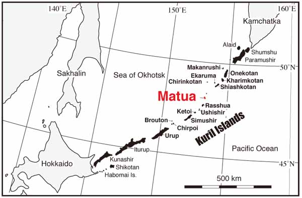
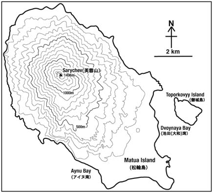
Sarychev Peak, an active volcano at 1496m, is located in the center of oval-shaped Matua Island extending in the northwest-southeastern direction of a diameter 12*6 km, Kuril Islands. Rock type of the volcano is basalt - andesite.
Sarychev Peak is one of the most active volcano in the Kuril Islands, which has been frequently observed to erupt in 1760's, 1878-79, 1923, 1930, 1946, 1954, 1960, 1976, 1986, 1989 and 2009 since the mid-18th century (Gorshkov, 1970; Simkin and Siebert, 1994). Gorshkov (1970) reported that the eruption in 1946 was so devastating that the pyroclastic fall deposits covered over almost all the eastern foot of the island, completely destroying the vegetation. The pyroclastic flow deposits flowed down to the northwestern seashore. The scale of the eruption is estimated at VEI (Volcanic Explosive Index) =4 (Simkin and Siebert and 1994). This is one of the largest-scale eruptions in the Kuril Islands during the 20th century. Other known eruptions of VEI=4 in the Kuril Islands during the 20th century are; Raikoke Volcano in 1924, Tyatya Volcano in 1973, Alaid Volcano in 1981 and Chikurachki Volcano in 1986.
Photographs of Sarychev Peak (click to enlarge)
.jpg)
.jpg)
.jpg)
.jpg)
.jpg)
.jpg)
.jpg)
.jpg)
.jpg)
.jpg)
.jpg)
.jpg)
The author had opportunities to visit Matua Island in 2008, 2007 and 2000, and observed that white smoke was rising from around the summit in 2007 and 2008. In 2007, good weather allowed slightly bluish white smoke to be seen, which indicates high volcanic gas concentration in the smoke. A Russian volcanologist mentioned that volcanic glow was observed.
Thick scoria fall deposits and lahar deposits on the east coast of Matua Island might contain ejecta of the 1946 eruption, judging from the thickness of the soil and the eruption record after Gorshkov (1970). Matua Island has been an uninhabited island since the Russian army drew off in the 1990's.
These pictures were taken during the IKIP2000,KBP2007 and KBP2008. I appreciate U.S. National Science Fundation (ARC-0508109; Ben Fitzhugh, PI), Univ. Washington, Sakhalin Regional Museum, Far East Branch of the Russian Academy of Sciences, Hokkaido Univ. and Historical Museum of Hokkaido.
Location and Topography of Sarychev Peak