
We live by building above (or below) ground and using underground resources. Therefore, it is important to know what is going on in the ground (underground) that supports it. However, it is not easy to know the subsurface, even if it is only a few centimeters. Therefore, we are engaged in geophysical research to clarify the geological structure of the subsurface.
Active fault structure in the Mikawa Bay area, Aichi Prefecture, Japan
|
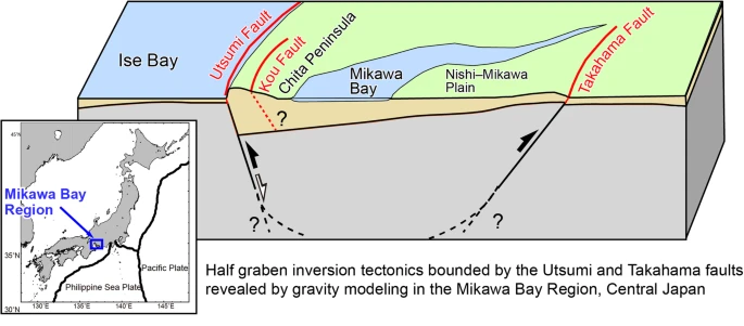
In a study to explore the subsurface in the Mikawa Bay area of Aichi Prefecture, we used gravity data to estimate the depth and structure of the subsurface basement. This research revealed the active fault that forms the Chita Peninsula (Utsumi Fault) and the active fault that lies subterranean in the Nishi-Mikawa Plain (Takahama Fault), and revealed how complex this region is and how it has been greatly changed by crustal movements in the past. In particular, the Takahama Fault may have played a significant role in the occurrence of the 1945 Mikawa Earthquake. This is an important finding for earthquake assessment and geological understanding. See: Miyakawa et al. (2020) AIST press release was issued on this research. [AIST website] |
|
Mt. Aso magma reservoir and the 2016 Kumamoto earthquake
|
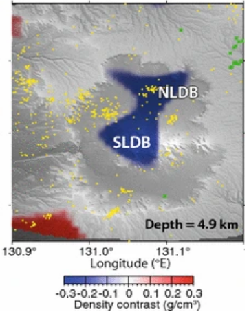
Mt. Aso in Kyushu, Japan, is a magma reservoir beneath the mountain, and we investigated how it is related to the 2016 Kumamoto earthquake.
The location of the magma reservoir on Mt. Aso identified in this study coincided with the location where seismic slip along the Futagawa Fault stopped during the 2016 Kumamoto earthquake.
This suggests that the rapid fault displacement during the earthquake stopped at the magma reservoir.
This study provides a clue to understanding the relationship between volcanic activity and earthquakes. See: Miyakawa et al. (2016) |
|
Gas (methane) hydrates in the Nankai Trough Kumano-nada
|
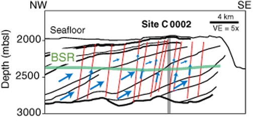
Deep-sea drilling in the Nankai Trough Kumano Basin has been used to investigate the existence of gas hydrates (methane hydrates) and their saturation.
We clarified how this gas migrates from deep underground, shedding new light on the gas cycle in the Earth's interior.
This knowledge will contribute to natural resource exploration and scientific research. See: Miyakawa et al. (2014) We won the Island Arc Award from the Geological Society of Japan for this research. [Geological Society of Japan website] |
|
Production and publication of "Gravity Anomaly Maps"
|
In order to clarify the underground geological structure of the whole country of Japan, AIST has been producing "Gravity Anomaly Maps" for several decades. The "gravity anomaly" is a property that varies with the "density" of materials in the subsurface, allowing us to determine the weight of materials in the subsurface. A field survey using a gravimeter is necessary to investigate gravity anomalies. We conduct gravity observations not only in urban areas and plains, but also in rugged areas such as mountains and oceans, and create "Gravity Anomaly Maps" for the entire country.
See: AIST Gravity Map Series (Bouguer Anomalies) This research was published in AIST Research Introduction. [AIST website] |
|