last update 2021.07.28
Geochemical map is initially prepared for mineral exploration in a small area. Recent interest in environmental problems has led to the utilization of geochemical maps for environmental assessment. Many countries have published nationwide geochemical maps and high-density geochemical maps in urban area mainly for environmental assessment. Cross-boundary (a sub-continental scale) geochemical mapping projects have been also conducted. Japan locates in island arc region and is surrounded by the sea. For Japanese geochemical mapping project, about 3,000 river sediments and 4,900 surface marine sediments around Japan have been collected and analyzed for 53 elements including toxic elements. Regional elemental distribution in both the land and the sea has been determined. Applying such comprehensive geochemical maps, we can elucidate geochemical baseline across the land to the sea.
Influence of geology and mineral occurrences on geochemical maps is elucidated using a geoinformation system (GIS) and a statistical analysis. Stream sediments collected for geochemical mapping are grouped by a parent lithologies using watershed analysis. The correspondence of elemental abundance in stream sediments with surface geologies is confirmed by an analysis of variance (ANOVA) and a multiple comparison test. As a whole, the following association has been recognized.
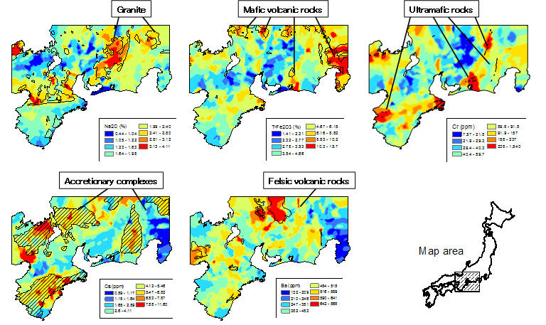
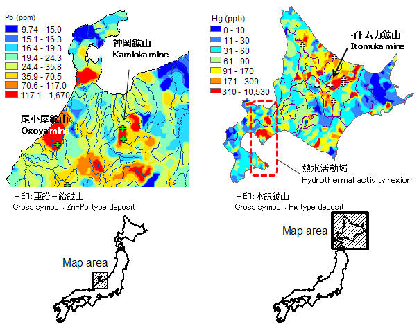
The very high concentrations of heavy metals such as Cu, Zn, Cd, and Pb are detected around mineral deposits. But, their geochemical anomalies disappear quickly downstream from the mineral deposits (see Pb map). This indicates that a large amount of stream sediment is supplied from watersheds without mineral occurrences: active erosion resulting from high rainfall and steep mountains conceals its impact on elemental abundance. The right figure shows that influence of mineral deposits and volcanic activity on Hg map. Extremely high concentrations of Hg downstream from the Itomuka mine suggested that the Hg minerals flow down the river from the mine in large quantities. However, in general, it is difficult to detect extreme geochemical anomalies related to mineral deposits in Japan unless the stream sediment sample is collected just downstream from the mineral deposit.
High-density geochemical maps in urban area have been also prepared. As pilot studies, geochemical maps in Yamagata and Sendai cities in northern Japan have been created using stream sediments to elucidate human activity on geochemical maps.

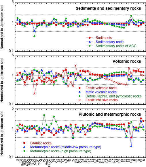
Geochemical maps have been applied to provenance studies, such as those for food and agricultural production, migration analyses in archeology, and forensic investigation. It is important to know information about the parent lithology in addition to chemical compositions of sample media because research subjects closely relate to surficial rocks. Thus, we estimate mean chemical compositions of stream sediments classified by the dominant lithology in the watershed. The new datasets are summarized by Ohta et al. (2021) Geochem. J. 55, 59–88.
Geochemical map in marine environment is controlled by many factors:1) grain size (changing mineral composition), 2) particle transfer from land to sea, 3) bathymetric features, 4) oceanic currents/tidal currents, 5) relict sediments, 6) early diagenetic processes, 7) biogenic matters, 8) volcanic activities, 9) anthropogenic activities, 10) antigenic minerals, and so on.
Elemental concentrations of marine sediments largely change depending on grain size classification. Most of the elemental concentrations increase with the decrease in the grain size, and become constant at silty and clayey size particles. The effect is ascribed dominantly to the dilution effect by quartz and calcareous materials (see the variation of CaO concentration). High concentrations of Mn (MnO) and Fe (total Fe2O3) in coarse and medium sands indicate the Fe-Mn (hydro-)oxides coating on quartz, plagioclase and lithic fragments.
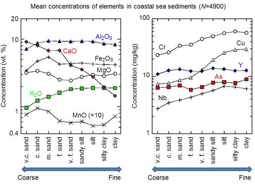
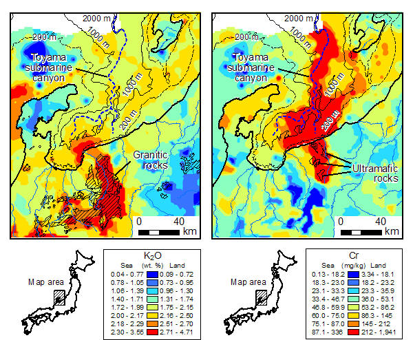
K (K2O) and Cr maps in central part of Japan are good examples of visible particle transfers from land to sea. Granitic rocks provide coarse sands enriched in Na (Na2O), K (K2O), Rb, REEs and so on. High K (K2O) concentration area corresponds to the distribution of granitic rocks. Coarse sands rich in K (K2O) transport through the river to the coastal sea. But, the most of them are deposited near the river mouth as a fan-like form. They are not transported over a long distance. In contrast, ultramafic rocks composed of serpentine provide very fine sands and silt that are highly enriched in Mg, Cr, Co and Ni to the rivers, although the rocks sporadically distribute in the region. These very fine particles do not deposit soon when they are supplied from the river to coastal seas. It takes long time to deposit on the sea floor, so that fine particles are dispersed widely by tidal waves and oceanic currents. Furthermore, submarine landslide conveys sediments rich in Mg, Cr, Co and Ni along the deep submarine canyon as far as over 60km.
Geochimical map of Sea and Land of Japan: Database provides geochemical maps of 53 elements in the land and the sea of Japan and information about samples (such as textile of samples and photos).